Architect: Bertrand Goldberg
Location: Chicago, IL
Dates: 1972-1986
Owner: Commonwealth Edison
Program: Commercial, Parking, Marina, Residences
449 units
Overview
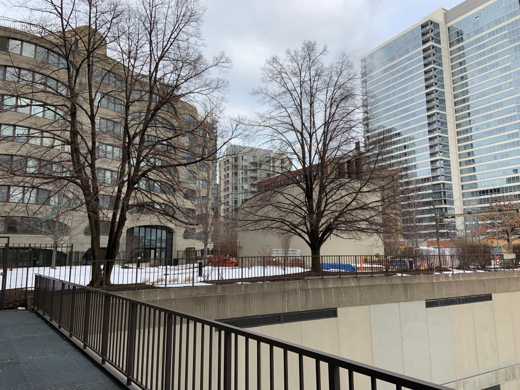
River City is a mixed-use building at 800 South Wells Street in Chicago, Illinois. Designed by Bertrand Goldberg, architect of Chicago’s Marina City towers, it was completed in 1986. The building is constructed on a post-industrial site next to the Chicago river and is formed with two 7-14 story towers arranged in an S shape. These towers sit on a plinth of columns that hold the southern portion of the building above the Chicago River, creating a marina for the residents.
History
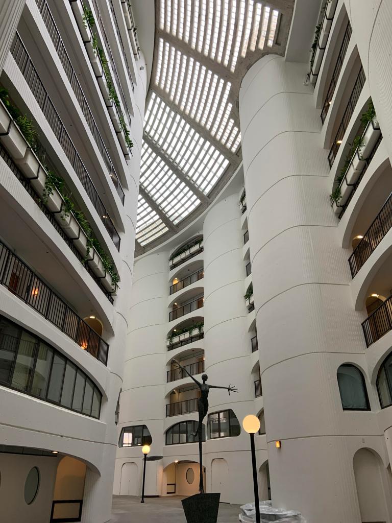
River City went through several design phases between 1972 and its realization in 1986. Originally the design entailed of several 72 story towers grouped in threes. Goldberg wanted to provide residents with an extensive range of services within the facility to provide for simple and complex everyday needs. The building was converted to condos in 2001-2006, but two years ago was purchased by investors in order to turn the building back into apartments. Many changes are being made to the commercial and mixed use ground floors. The project received complaints from preservationists when the exposed concrete atrium was painted white.


Response and Analysis
This building is interesting in that it incorporates many of Goldberg’s ideas of creating a city within a building. Two stacks of apartments are placed side by side and curved into an S shape, creating an interior “street” which is shared by all of the occupants. This “river road” is then stacked on top of a plinth of mixed use and office spaces. The building attempts to revitalize the post-industrial railyard lot and re-engage citizens and residents with the river which was formerly monopolized by industry for shipping and waste-dumping. This is accomplished in part by constructing the southern portion of the building above the river and creating a marina underneath.
The building might be a good example of lamination, in that the residential units create a sandwich with public space and circulation in the center. It also makes use of merging in the way that it takes residential spaces and commercial spaces and creates opportunities for them to come together.

Detail Model


Concept Models


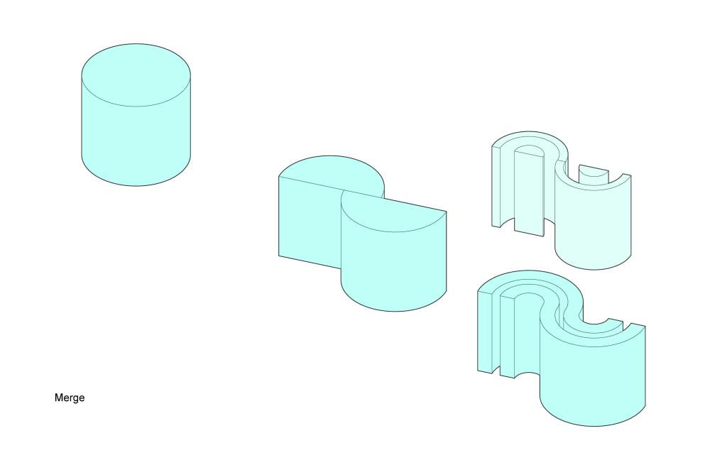
The sharing verbs we talked about in our presentation were “merge” and “laminate.” The building merges public and private space by stacking the units atop a plinth that combines commercial offices, retail space, and amenities for residents. The building laminates the two residential towers with a central shaft of open circulation space.

Luke and Andi,
Starting with your diagrams: the simple 3D graphics read well, lamination makes total sense, and merge as you wrote about could make sense, as could the diagram you labeled merge I’m just not sure the diagram and the text go together or that both are “merge”.
1. Like many of the projects I think you may need to create your own site diagram from an aerial photo: to get context, solar orientation, the river… at a scale you can use to talk about big-scale site issues. How does the s-shape relate to its context? Secondarily, how does the plinth work, both to the exterior of the site, and towards the residential uses? How about the marina and river’s edge?
2. I’d like you find/draw a section that shows the different levels at the base: grade, river, river-walk, the various levels of the plinth, up to the “river road” (base of the atrium) and relates them architecturally to the level where the exterior wall transitions from the Goldberg columns to the corncob walls above. Even if there are changes underway or others made in the past to the plinth, generally speaking I think we should understand how it relates to the residential zone: is there a clear vertical separation, a transitional zone, overlap…that can be understood and diagrammed. Programmatically I’m also wondering if the base of the atrium is flanked with residential units or if other programs are present.
3. How do the residents use that “street” is it part of their arrival at the tower or day-to-day circulation? More generally, how do they arrive on site and circulate to their building? How does the public circulate through the site? (diagrams)
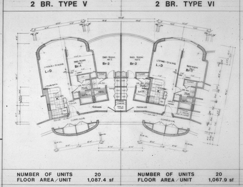
4. It seems like you’ve almost got enough information to piece together a typical residential floor: although it would help to have the unit plans for the townhouse type units. But without more and better drawings of the other levels I’m not sure how you proceed. I’m hoping you’ve got someone from Goldberg sending you drawings or an interlibrary loan request out or both. If not run talk to Kim in the library asap.
5. Moving back to the diagrams and the “sharing verbs”, you’ve started on the scale of the tower. The project also seems rich in opportunities at the scale of how the units aggregate or are formally expressed with the corncob exterior and the way the interior circulation paths work. Will you diagram this formally as well?
Goldberg can be challenging to fit into a simple tale of architecture and modernism but you’ve touched on a couple key contextualizing elements we could understand better:
6. The context of downtown Chicago in the 1970’s and 1980’s: What neighborhoods were seeing investment and growth then, particularly residential? What was the perception of this area of the city? Prior to this era, what was happening to the light industry and railroads serving them in downtown Chicago?
7. Who was Bertrand Goldberg? How was he perceived at that time by his peers, by the press, the broader population?
8. In addition to the idea of the “river street” was there more to Bertrand Glodberg’s story of this project: why his design was appropriate, or just why it was the way it was?
LikeLike